Follow-up measures
The wind farm off the coast of Saint-Brieuc Bay, supported by Ailes Marines , obtained on April 18, 2017, from the Prefecture of Côtes-d'Armor, the administrative authorization known as "Single IOTA Authorization" under the provisions of the articles L.214-1 et seq. of the Environmental Code.
This authorization prescribes several environmental monitoring, reduction, compensation or support measures. The aim of the monitoring measures is to monitor the evolution of the environment over time, and to measure the impact of the wind farm on this evolution.
Visual monitoring of marine mammals and birds
During construction:
Disturbance due to noise
Loss of habitat
Risk of mortality/injury due to noise
Masking of communications due to noise for marine mammals
Photoattraction (increased collision risk + exhaustion) for birds
During operation:
Photoattraction for birds
Collision risk and barotrauma for birds
Disorientation by ultrasonic emission for birds
Electromagnetic fields for marine mammals
Other effects on marine mammals negligible
The main objective of the “visual” monitoring of marine mammals and birds is to determine the impact of the work and operation of the wind farm off the coast of Saint-Brieuc Bay on these groups. These monitoring will also improve local knowledge.
Boat observations are carried out by two observers simultaneously, each covering one side of a boat and focusing on a 300 m swath. A transect-type protocol is also deployed for high-definition aerial monitoring. The films made during outings are analyzed back on land.


Schedule and Status
Measure currently implemented
This surveillance measure will be implemented several times:
Between March 2020 and March 2021:
Between March 2020 and 2025:
In the operating phase (after 2025):
Passive acoustic monitoring of marine mammals
During construction:
Disturbance due to noise
Loss of habitat
Risk of mortality/injury due to noise
Masking of communications due to noise
During operation:
Electromagnetic fields for marine mammals
Other negligible effects
The objective of “passive acoustic” monitoring of marine mammals is to provide information on the activity of cetaceans in the area of the offshore wind farm before work (reference state), during the construction, operation and dismantling phases.
Seven acoustic stations are positioned at different locations in the study area, each recording high frequencies (porpoises, clicks) and low frequencies (low and medium frequency cetaceans, ambient noise). Two stations are positioned in the park, and the other five are arranged in a star pattern around the park at 10 and 20 km distance.
Registration is effective 33% of the time. Equipment maintenance is carried out approximately every 3 months and the data obtained is processed back on land.

Mammal tracking buoys
10 km around the buoys
Implementation area
10 km around the location area
20 km around the location area
Schedule and Status
Measure currently implemented
This monitoring measure will be implemented several times:
- between March 2020 and 2024
- 1 year of follow-up (date to be defined)
- 1 year of follow-up (date to be defined)
– between March 2020 and 2024: pre-construction phases, construction and the first 2 years of operation
– 1 year of monitoring (date to be defined): half of the operating period
– 1 year of monitoring (date to be defined): the year preceding the dismantling of the park
Monitoring of nesting colonies
During construction:
Habitat loss/modification
Photoattraction
Disturbance from ships
Risk of collision with ships
During operation:
Risk of collision
Loss / Modification of habitat
The objective of the measure is to improve knowledge of the nesting colonies in the Bay of Saint-Brieuc. This monitoring is not intended to replace actions already carried out in the territory, but to complement them in order to refine knowledge of local nesting colonies.
The scientific protocol establishing the technical modalities of field actions was established jointly between Ailes Marines and local stakeholders (Bretagne Vivante, GEOCA, Syndicat Mixte Grand Site Cap d'Erquy Cap Fréhel, and VivArmor). The coordinator of the implementation of monitoring is GEOCA. The 7 Islands site was ruled out after discussions with the LPO because the latter is already particularly well followed and known.
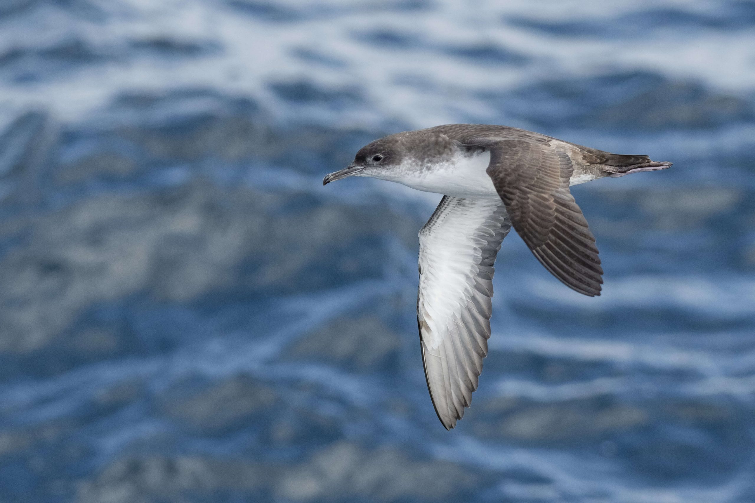
All species of nesting birds are monitored, and more particularly Great Cormorants, Gulls, Storm Petrels, Shearwaters, Alcidae, Black-legged Kittiwakes and Terns.
Great Cormorant
Herring gull
storm petrel
Balearic shearwater
Alcidae
Kittiwake
Tern


Generally speaking, three types of monitoring have been identified:
Once analyzed, the data will be stored in a public database (ORA).
Monitoring will be carried out in five colonies: Fréhel, Verdelet, Bréhat, Plouha and Cézembre.

Schedule and Status
Measure currently implemented
Seven years of monitoring are planned, according to the following schedule:
2020
- In the pre-construction phase 87%
2022
- In construction phase 0%
2024, 2025, 2026, 2034, 2044
- In the operating phase 0%
Monitoring the dispersal of alcid chicks
During construction:
Habitat loss/modification
Photoattraction
Disturbance from ships
Risk of collision with ships
During operation:
Risk of collision
Loss / Modification of habitat
The objective of the measurement is to improve knowledge of the phenomenon of dispersal of adults and their chicks at sea, and to verify whether this dispersal is carried out in the direction of the wind farm off the bay of Saint-Brieuc.
The scientific protocol establishing the technical modalities of field actions was established jointly between Ailes Marines and local stakeholders (Bretagne Vivante and the Syndicat Mixte Grand Site Cap d'Erquy Cap Fréhel). Follow-ups will be carried out:
The observation data are used under GIS and will make it possible to produce a map showing the location of male-chick duos along the transects covered.

On Earth near Cap Fréhel

At sea, for transects starting from the tip of Cap Fréhel
Schedule and Status
Measure currently implemented
Five years of monitoring are planned, according to the following schedule:
2020
- In the pre-construction phase 87%
2022
- In construction phase 0%
2024, 2025, 2026
- In the operating phase 0%
Monitoring of avifauna by terrestrial radar
During construction:
Habitat loss/modification
Photoattraction
Disturbance from ships
Risk of collision with ships
As the offshore radar can only be functional when the wind turbines are energized, monitoring by terrestrial radar is set up before and during construction. Specific monitoring will be implemented to assess micro/macro avoidance as well as migratory flows within the park during the operational phase (see following sheet).
The main objectives of this monitoring of avifauna by terrestrial radar are to evaluate potential changes in the behavior of seabirds due to the presence of the park and to measure the migratory flow in order to better understand the importance of passages in bay of Saint-Brieuc.
A radar system is therefore installed on the Cap Fréhel site (point of the coast closest to the park) during the two main bird migration periods (April and October). For each monitoring, the radar system (vertical mode and horizontal mode) continuously measures migratory flows and flight heights over a period of one week.

Schedule and Status
Measure currently implemented
This follow-up measure will be implemented several times:
One week in October and one week in April each year (migration periods) during the pre-construction and construction phases.
Monitoring of avifauna by maritime radar
During construction:
Actual habitat loss due to avoidance
Attraction by construction lights
Disturbance from noise and boats
During operation:
Collision risk
Photoattraction
Actual habitat loss due to avoidance
Disturbance from noise and boats
Monitoring of avifauna by maritime radar will be carried out using an automated radar/camera system, installed in the park, allowing maximum coverage of the park surface as well as good data acquisition. Vertical data provides information on flight height while horizontal data provides information on lateral trajectories/directions. These two pieces of information are important to see if the birds change their flight height, avoid the wind turbines laterally, enter directly into the park, and leave again.
The two main objectives are:
It was initially planned to install a radar during the pre-construction phase, construction and the first years of operation on a foundation, i.e. for 6 years. This is not possible for technical reasons (no offshore platform or electricity before commissioning). Ultimately, Ailes Marines will install 1 land radar during the migration period for 4 years (pre-construction and construction) and two radars at sea for 2 years.
Currently Micro Shelter Solution is working for Ailes Marines on the definition of this system (location, type of radar, coverage, dual navigation/avifauna vocation, configuration, maintenance, etc.) and the latter will be presented for information to the members of the CS.

Two radars will be installed within the park, one to the north on foundation no. 57, and the other to the south, the location must still be validated with regard to the technical installation constraints, but it could a priori be foundation no. °9.
Schedule and Status
Measure under development
This monitoring will begin when the wind turbines in the park are commissioned and for a period of 2 years during the operating phase of the park.
Telemetric monitoring of gannets
During operation:
Risk of collision
Loss / Modification of habitat
The objective of the measure is to improve knowledge of the ecology of the gannet in the bay of Saint-Brieuc. This monitoring is not intended to replace actions already carried out in the territory, but to complement them in order to refine knowledge of local colonies.
The field work will take place in Sept-Iles, but the data collected will allow detailed monitoring of their movements and fishing activities throughout the Channel. Adult Gannets will be captured in Sept-Iles, during the breeding season. They will be equipped with the latest generation electronic devices allowing detailed monitoring of their movements on a small and large scale, their flight altitudes and their use of the project area.
This equipment will consist of:

This measure will be implemented through close collaboration between the Sept-Iles nature reserve and the CEFE-CNRS of Montpellier. This collaboration, in place for several years, has made it possible to validate and refine all of the protocols that will be used for this work, as well as all the logistical arrangements.

The capture and fitting of gannets will be carried out within the Sept-Iles reserve.
Schedule and Status
Measure under development
Monitoring will take place over three years:
- one year in construction phase
- two years at the start of operation
– one year in the construction phase (2023)
– two years at the start of operation (2024-2025)
Each year, monitoring will take place over a period of 3 months, which includes two and a half weeks of data collection on the Northern Gannets of Sept-Iles (June) as well as two and a half months of preparation of field work, data analysis and drafting of the annual report (June – July – August).
Telemetric monitoring of alcids
During construction:
Habitat loss/modification
Photoattraction
Disturbance from ships
Risk of collision with ships
During operation:
Risk of collision
Loss / Modification of habitat
The measure concerns nesting Torda Penguins and Common Guillemots in the Cap Fréhel colony. The aim is to clarify the ecology of these two species and to learn more about the behavior of these birds in relation to the construction and operation of the park.
The objective is to equip 10 to 15 individuals of Penguins and Guillemots per year, for 3 years, with miniaturized electronic devices during the breeding period.
Field work will take place at Cap Fréhel, with the birds immediately released on site as soon as the GPS is installed, then recaptured a few days later to recover the equipment. The data collected will allow detailed monitoring of their movements and their fishing activities in the Norman Breton Gulf.
The following deliverables will be produced:
Data
Cards
Kernel spatial analysis
Temporal analysis
Monitoring will be carried out in collaboration between the Regional Avifaune Observatory (ORA), Bretagne Vivante, the Caps union and the University of Nantes.
The capture and fitting of the Alcidae will be carried out near the cliffs of Cap Fréhel.
Schedule and Status
Measure under development
Monitoring will take place over three years:
- one year in construction phase
- two years at the start of operation
– one year in the construction phase (2023)
– two years at the start of operation (2024-2025)
Monitoring will take place over a period of several months, which will include the collection of data on the alcids of Cap Fréhel as well as the preparation of field work, data analysis and writing of the annual report.
Benthos/water/sediment monitoring
During construction:
Resuspension from drilling discharge (turbidity)
Deposition of sedimentary particles
Crushing (presence of piles and protections, anchoring of ships, installation and protection of cables)
During operation:
Loss or modification of habitats
Degradation of water and sediment quality
Reef effect
This multiple monitoring has 3 distinct compartments, benthos / water / sediment is divided into 3 sub-parts:
A. Bio-assessment of benthic macrofauna and geochemical characterization of sediments
This involves monitoring epifauna and infauna around 4 stations, representative of the diversity of habitats present on the study site. Two stations are located on soft substrates, two on substrates considered hard. Each of these stations is made up of 4 substations, positioned following a potential incidence gradient in the major axis of the current.
– Loose substrates: Sampling using i) a standardized grab (0.1m2; 5 replicates) and ii) a towed video system allowing transects to be carried out. An average sample of sediments will be taken for geochemical analyzes in the laboratory.
– Hard substrates: Production of a fixed point video sequence lasting 10'.
B. Monitoring water quality and water mass
Sampling of sea water at 1 station located in the central position of the wind farm perimeter.
Sampling using a Niskin trigger bottle. The sample is constituted at a single average depth.
C. Monitoring the impact of sacrificial anodes
Task 1: Quantification of anode corrosion products in the environment (seawater, sediments). This “task” (field/dosage) is fully integrated into the monitoring protocol for water quality, water bodies and sediments.
Task 2: Assessment of the health and environmental risk induced via potential mechanisms of bioaccumulation of aluminum and zinc.
The species monitored as part of this monitoring are the scallop (Pecten maximus), a filter-feeding bivalve, the whelk (Buccinum undatum), a scavenger gastropod and the common pout (Trisopterus luscus), a predatory fish. The sampling effort for these species comes from experimental fishing carried out during the monitoring of fisheries resources.


Schedule and Status
Measure implemented
Monitoring will take place according to the following schedule:
- Monitoring of benthic biocenoses in September
- Complete monitoring at the start of operation
- Punctual follow-up
– Monitoring of benthic biocenoses in September between 2020 and 2023,
– Complete monitoring at the start of operation, from 2024 to 2026,
– Punctual monitoring every 5 years.
Monitoring of fisheries resources
During construction:
Crushing (presence of piles and protections, anchoring of ships and laying and protection of cables)
Resuspension of sedimentary particles and their deposition
Noise pollution and vibrations
During operation:
Habitat modification
Reef effect
The objective of this monitoring is to evaluate the impacts of the construction and operation of the offshore wind farm and its connection on the fishery resource (monitoring shared with RTE. To do this, the comparison between the reference state and The environmental monitoring carried out throughout the life of the project must make it possible to decide on the effects of the project on the fishery resource.
Several follow-ups are implemented:
Experimental fishing
Tides observed
Analysis of existing data
Specific monitoring of cuttlefish spawning
The list of species monitored goes beyond regulatory requirements, it has been validated with the Fisheries Committee 22 and includes the following species:
- Bentho-demersal species using a frank trawl (soft substrate) and a Canadian trawl (hard substrate);
- Large shellfish in the shellfish trap or shellfish net;
- Bivalves other than scallops at the Hamon bin;
- Scallops using a flap dredge (soft substrate) and a roller dredge (hard substrate);
- The whelks in the locker;
- Adult cuttlefish in the trap (on-board observations), as well as monitoring of spawning (laying of lines).
In addition to experimental fishing, on-board observation campaigns are carried out for most professions with professionals working in the bay of Saint-Brieuc, and more specifically in sectors close to the site of the future wind farm and its connection. . These campaigns (around 70 per year since the end of 2019) aim to obtain additional indicators.
The selection of stations was carried out in two stages:
- Areas more or less close to the field were selected to evaluate the impacts of the work and the operating phase according to a gradient of incidence
- Specific stations have been defined within its areas in consultation with the CDPMEM22 (in particular on the basis of knowledge of the fishing zones)

Location of sampling stations with the frank trawl (soft substrate) and a Canadian trawl (hard substrate) and types of vessels used.

Location of crustacean net sampling stations

Location of bivalve sampling stations at the Hamon bin

Location of scallop sampling stations using the flap dredge (soft substrate) and the roller dredge (hard substrate)

Location of whelk sampling stations at the locker

Location of cuttlefish spawning sampling stations
Schedule and Status
Measure implemented
The mission execution schedule was defined in consultation with the CDPMEM22 which proposed target months for each species, based on the practice of professionals. Please note that the months selected may vary, notably depending on the weather, the availability of fishing professionals with whom the service providers embark, etc.
Follow-ups are planned:
- In September and February for bentho-demersal species
- In October and November for spiders
- In September for bivalves and scallops
- In March and June for whelks
- From March to June for cuttlefish
Monitoring by experimental tide began in September 2018 for the reference state before work, will continue during the construction phase between 2021 and 2023 and also the first 3 years of operation, i.e. from 2024 to 2026 then every 5 years ( years n+1, n+2, n+3, n+5, n+10, n+15, n+20, n+25).
Additional monitoring has been carried out since the end of 2019.
Monitoring the reef effect
During operation:
Positive reef effect for pelagic species and larvae
Positive reef effect for benthic species (scallops, bivalves, whelks, spiders and bentho-demersal fish)
Positive reef effect for soft and hard substrates
The objective of this monitoring is to evaluate the reef effect of the foundations and to analyze the appearance of non-native species and in particular a possible proliferation of crepidula. In fact, the foundations will constitute a new vertical support favorable to the colonization of hard substrate species, which will need to be monitored. It is therefore proposed to follow over time the dynamics of colonization of structures as well as the progressive evolution of species.
Monitoring will be carried out using an ROV and/or divers. The choice of monitoring technique will depend on the regulations which will be defined by the competent State services, in particular regarding the authorization to dive or not within the park.
7 foundations will be monitored and defined according to the nature of the substrates, distributed as follows:
• 2 foundations on medium sand, to the south of the installation area;
• 2 on the stones, in the center of the installation area;
• 2 on the rock to the north of the implantation area;
• The foundation of the electrical substation.

Schedule and Status
Measure under development
This monitoring will be carried out according to the following schedule:
- For 5 years at the start of operation
- Punctual follow-up
– During the first 5 years of the operation phase (from 2023 to 2028)
– Once every 5 years thereafter.
Monitoring of crepidula
During operation:
Crepidula proliferation
The objective of this measure is to monitor the risk of proliferation of crepidula by relay effect following the potential colonization of foundations. Indeed, the larvae of invasive species, such as the crepidula, could find a support at the foundation level which would act as a relay in the expansion of invasive species by offering new substrates for their installation. A monitoring measure specific to crepidula is therefore proposed in order to characterize their presence and the extent of colonization. In the event of a significant presence, a negative effect would then be noted, provided that their presence on the foundations induces an expansion of the crepidula shoal in Saint's Bay.
The results of monitoring the colonization of foundations (Reef Effect) will make it possible to identify the presence or absence of invasive species such as crepidula. Also, based on the results, specific monitoring of crepidula will or will not be implemented.
The monitoring measures will consist of these 3 steps:
Step 1
2nd step
Step 3
Schedule and Status
Measure under development
This monitoring will be implemented once, over a year in the operational phase and may be renewed depending on the results.
Monitoring bats during the construction phase
During construction:
Attraction of bats by construction lights
The methodology consists of equipping a ship as well as the Grand Léjon lighthouse with an acoustic system including an acoustic recorder, a microphone and a solar panel to power the system in order to evaluate and characterize the activity bats in the park area and surrounding areas. The objective is also to identify whether the construction site is a source of light attraction for bats and in particular the Nathusius Pipistrelle.
The acoustic recorders that will be used will have the particularity of detecting ultrasound over a previously defined range of frequencies and recording them.
The parameters that will be searched will be:
A methodology similar to that used during the initial state will be implemented.
This measure will be carried out in partnership with Phares et Balises.

Schedule and Status
Measure under development
Monitoring will take place during bat migration periods, i.e. in spring and fall in 2021, 2022 and 2023.
Monitoring bats during the operational phase
During operation:
Risk of collision / barotrauma
Photoattraction
In the operational phase, 8 wind turbines will be equipped with acoustic recording stations (ultrasound) in order to evaluate and characterize the activity of migrating bats in the park area.
This monitoring aims, among other things, to provide information on the presence of the Nathusius Pipistrelle migrating in the offshore wind farm. The latter having been detected at the Grand Léjon lighthouse but never in the park area.
This monitoring will also provide information on whether the wind farm in operation constitutes a source of light attraction for bats.
To do this, 8 wind turbines will be equipped with acoustic recording stations (ultrasound). These stations are distributed around the outskirts of the wind farm (see figure below).
Eight acoustic recording stations will be distributed among the peripheral wind turbines within the park. Positions 50, 61, 47, 38, 12, 3, 4 and 25 are currently preferred.

Schedule and Status
Measure under development
This monitoring will constitute a continuation of the bat monitoring during the construction phase. It will also take place during bat migration periods, in spring and fall. It will begin when the wind turbines in the park are commissioned and for a period of 3 years during the operating phase of the park, i.e. in 2024, 2025 and 2026.
Monitoring of fishing activities
Fishing activity in the bay of Saint-Brieuc represents an important part of the local economy. The objective of monitoring fishing activities is to evaluate the evolution of the fishing fleet and fishing practices, from an economic point of view, in order to determine the impact of the wind farm on this activity.
A similar study on fishing activities near the settlement area was carried out in 2013 as part of the Ailes Marines project.
Monitoring will focus on a study of the evolution of the fishing fleet (numbers, fleet structure, professions) in the bay of Saint-Brieuc, as well as a study of fishing practices (fishing zones according to professions). ).
The data analyzed to present the fleet in the bay of Saint Brieuc and its surroundings will come a priori from the VALPENA tool and will include:
- Data concerning maritime districts;
- Data from statistical rectangles.
The data will be based on surveys carried out in year “n” which will make it possible, after processing, to obtain cartographic and statistical information on fishing activities in year “n-1” by rectangle, within the Bay of Saint Brieuc.
The definition of the contours of the measure is currently being discussed with the Côtes d'Armor Maritime Fisheries and Marine Farming Committee (CDPMEM 22). The protocol for this monitoring will be defined jointly between the CDPMEM22 and Ailes Marines .
Schedule and Status
Measure under development
The implementation protocol for this measure will be defined during 2020.
Monitoring of airborne noise during the piling phase
During construction:
Noise in the air on land
The objective is to measure airborne noise on land during the construction phase during piling operations. The same measurement points as during the initial state in 2015 will be considered, namely:
- Point 1: Erquy
- Item 2: Binic
The measurements will be carried out throughout the duration of a threshing phase and a few hours before and after using a sound level meter per measuring point including a preamplifier and a microphone.
The measurements will be carried out in accordance with:
The NF S 31-010 standard
The draft standard NF S 31-114

Schedule and Status
Measure under development
Monitoring will be carried out during a piling session during the construction period between 2021 and 2023.
Monitoring of turbidity during the works phase
During construction:
Modification of water quality
Disturbance of fishery and benthic species
Disruption of uses
Modification of the transparency of the water column
The system is positioned on the real-time assessment of environmental risk and therefore focuses on the most immediate effects of pile drilling. Above all, it has an alert function which aims to interrupt or reduce the effects before they produce impacts.
Three alert levels for concentrations of suspended solids (MES) will be considered:
First level of alert: reinforced vigilance threshold
If this threshold is reached, a strengthening of control through the acquisition of specific data (at least turbidity, pH, continuous chlorophyll, MES analysis) will be triggered.
Second alert level: work adaptation threshold
Third alert level: work stoppage threshold
Measures to stop or reduce work will remain applicable as long as the MES concentration level has not fallen below 20 mg/l. Measurements will be taken 1.5 meters below the surface as well as 3 meters above the seabed.
Monitoring will comply with the requirements of the prefectural decree specific to turbidity.
Schedule and Status
Measure under development
The turbidity measuring stations will be positioned at least two months before the start of work, for a test phase, then will continuously measure turbidity during the installation operations of the foundations of the wind turbines of the offshore wind farm.
Photomontage after construction
The objective of this measure is to validate that the photomontages presented as part of the impact study were representative of the reality once the park was installed.
Photographs will be taken at the locations selected for the production of photomontages as part of the project. Just like when making photomontages, for several points of view, variations will be made:
- Variations depending on weather conditions;
- Variants illustrating the perception of the night project if possible.
The photographs will be compiled into a report and presented to local authorities as well as members of the CGS. They will be taken at the following locations:
- From the island of Bréhat to Pointe du Paon
- From Saint-Michel beach in Erquy
- From the tip of Plouézec
- From the D34 towards Pointe de la Guette in Plevenon
- From Saint-Quay-Portrieux beach
- From Beauport Abbey in Paimpol
- From the sea wall of Rosaires beach in Plérin
- From Port Moguer to Plouha
- From Pléneuf-Val-André beach
- From rue de la Mer in Plérin
- From Saint-Pabu beach in Erquy
- From the bottom of the bay of Saint-Brieuc in Langueux
- From Cape Erquy
- From the port of Binic
- From Sables d’Or beach in Fréhel
- From the Pointe de la Trinité (the Widows’ Cross in Ploubazlanec)
- From the D34 towards the Saint-Sébastien chapel in Pléhérel
- From Saint-Briac-sur-Mer
- From the countryside west of Plévenon
- From Elizabeth Castle in St. Helier
- From the Cap Fréhel lighthouse (Restaurant)
- From Bon Abri beach in Hillion
- From the Cap Fréhel lighthouse (Parking)
- From the Talbert furrow to Pleubian
- From the top of the Cap Fréhel lighthouse
- From Mont-Saint-Michel_west terrace of the abbey
- From the Fort de la Latte dungeon
- From the tip of Meinga in Saint-Coulomb
- From the tip of Saint-Cast
- Facing Erquy
- From Holland's stronghold in Saint-Malo
- Saint-Cast-le-Guildo
- From the Pointe de Corbière on the island of Jersey
- Off the coast of Fréhel
- From Plouha Point
- South of the park
- From Saint-Enogat beach in Dinard
- SW of the park
- From Pointe de la Garde Guérin in Saint-Briac-sur-Mer
- Grand Léjon
- From the D786 at a place called Bellevue, in Erquy
- Harbor Island
- From Pointe de Pléneuf to Pléneuf-Val-André
- Jersey Ferry Trip
The plan for identifying the points of view of the photomontages produced during the impact study will be used identically to produce the new photographs, using the same type of camera.
Schedule and Status
Measure under development
Completion after construction of the park, i.e. in 2024.